Dec 232010
 

By Dave Watt.

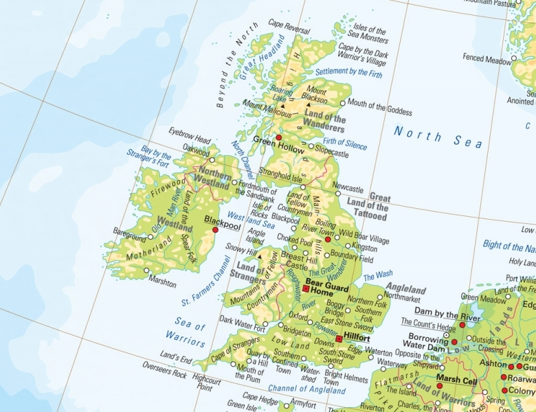
Agricola’s invasion of Scotland and the North of England in 83AD was accompanied by an extensive supply fleet which moved up the east coast of the country landing in rivers, inlets and bays. Being Romans and consequently, like conquerors everywhere, regarding themselves as being far more civilised than the hapless natives, they were inspired to name geographical features according to their own notions.

The east coast of Northern England was referred to as the’ Land of Tattooed People’ owing to the natives’ exotic and widely varied body decorations. In this the Iron Age farmers and hunters of the region were probably a bit more inventive and original than modern Premier League footballers who confine their tattoos to their girlfriend’s name written in really naff upper case Gothic text on the inside of their forearms. However, as there are sticks of rhubarb more capable of original thought than professional footballers this is very little for the Iron Age Geordie or Mackem to pat themselves on the back about.

Moving north into Scotland the modern Firth of Forth was referred to as the ‘Firth of Silence’ probably generating the ongoing Glaswegian calumny that there’s more life in a Glasgow funeral than at an Edinburgh wedding.  Pausing only to build a mega-fort at Inchtuthil near Dundee the combined fleet and the 9th Legion moved further north into the land of the Taexali eventually arriving at an area separated by two rivers.  The larger southernmost river the Romans called the Deva meaning ‘The Goddess’ and the nearby settlement at the estuary of the river was called Devana or ‘Mouth of The Goddess’.

Other Roman writings refer to it as variously Verniconam, Abredonia and Aberdonium at various points

This became a large supply port for the Roman army as they advanced up the coast and into the Grampian Highlands and was no doubt looked upon a beacon of civilisation to overawe the backward, selfish, and treacherous Philistines that inhabited the region.

In this it was largely successful for nearly two millenia until the Philistines had their revenge by building Norco House and have since tried to dump a million tons of concrete into Union Terrace Gardens.

Devana seems to have remained its name for several centuries – Ptolemy in 146 AD referring to the town as being the capital of the land of the Taexali whose tribal area which stretched from the Tay across the region and up towards the Keith/Banff area where the next tribe (the Vacomagi) lived. However, other Roman writings refer to it as variously Verniconam, Abredonia and Aberdonium at various points.

The next mention of the place is in a saga about a Viking jarl called Einar Skulason who’s longboats sacked and pillaged the place in 1153 where it is referred to in Old Norse as ‘Apardion’. The Vikings being men of action and very few words ‘Apardion’ actually means ‘The place where we rowed to for  three bloody days into the teeth of a North Sea gale and came away with a lump of very hard stone, a gourd of some greasy black stuff that tastes like shit and a big fish’*

Acta est fabula, Io Saturnalia

*Not really.

Dec 172010
 

By Bob Smith.

Div ye myn o’ Andrew Collies
Wi’ its waft o’ tea an’ coffee
Div ye myn o’ Thomson’s sweetie shop
Faar ye bocht aa kinds o’ toffee

Div ye myn o’ Cocky Hunter
Faar ye got maist onything
Div ye myn o’ Reid and Pearson
Weemin’s fashions they did bring

Div ye myn o’ Ledingham the bakers
Wi’ their restaurant up abeen
Div ye myn o’ the Princess Cafe
Faar ye looked oot ower the Green

Div ye myn o’ Aberdeen Motors
Faar ye bocht an Austin “Devon”
Div ye myn o’ Isaac Benzie
Faar yer mither wis in heaven

Div ye myn  o’ Pat McGee the tailors
Faa kept ye weel turned oot
Div ye myn o’ Milne an’ Munro
Faar ye bocht a leather shoe or boot

Div ye myn o’ Matheson the butcher
Wi’ his shops aa ower the city
Div ye myn o’ the Aberdeen Savings Bank
If ye hid money in the kitty

Div ye myn  o’ Paterson Sons & Marr Wood
Faar ye got a piano or an organ
Div ye myn o’ Gordon & Smith, the grocers
Faa selt spirits named Sandeman  or Morgan

Div ye myn  o’ yon Alexanders
Faar ye bocht bikes or radio sets
Div ye myn o’ Browns in Belmont Street
Faar  ye got fishin’ rods an’  nets

Div ye myn o’ the weekly Bon-Accord
Wi’ its pages printed in green
Div ye myn o’ The Rubber Shop
Faa selt fitba’ beets an bowlers’ sheen

Div ye myn’ o’ aa the ither shops
We’ve lost – mair is the pity
Div ye myn o’ aa the pleasure
Fit wis in the centre o’ the city

©Bob Smith “The Poetry Mannie”

Dec 102010
 

By Mike Shepherd.

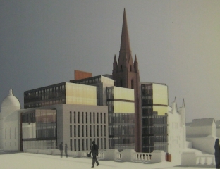
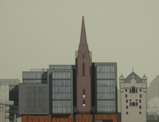
It may not be well known to the people of Aberdeen, but a major city-centre development is in the pre-application public consultation phase. This is the proposed office block development for the largely-derelict Triple Kirks site opposite the art gallery. The plan put forward by Stewart Milne Developments shows a 7 storey series of glass boxes set in a steel plinth and is partly granite cladded.

The plan also envisages two storeys of car parking with entry from the Denburn dual carriageway. The spire of the original Triple Kirks is to be kept and is shown sandwiched between two of the glass blocks.

The public consultation consisted of two sessions which were held on the 3rd and 4th of December. There is also a website, where comments can be made by the public as part of the consultation.

http://commercialdevelopments.stewartmilne.com/PageProducer.aspx?Page=3362

There has been very little in the local press about the development. The Evening Express showed a copy of the plans, but surprisingly given the importance of the site, no details were given in the Press and Journal.

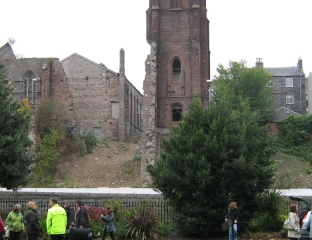
Alex Mitchell has provided me with a brief history of the building, which I quote here. “The Triple Kirks were built in 1843 following the Great Disruption in the Church of Scotland on the disputed issue of patronage – the right of the landed gentry to select ministers over the heads of congregations. About half the ministers and congregations in Aberdeen walked out and joined the Free Church of Scotland.   New ‘Free’ churches’ were built, often next door or across the road from those of the Church of Scotland, for example the churches of Queens Cross and  Holburn West.   There was considerable rivalry on such issues as the height of steeples. The majority of Free Church congregations had rejoined the Church of Scotland by 1929, but a rump remains – the ‘Wee Frees’.

The Triple Kirks – three separate churches built around a common spire – might be regarded as a kind of cathedral of the Free Church in Aberdeen, and was certainly about the size of a (small) cathedral. Designed by Archibald Simpson, it shows some similarity to the Elisabethkirche in Marburg,  brick-built churches being common in northern Europe.

Cost was a major consideration; and the bricks used are believed to have been recycled from the former Dee Village in Ferryhill on the site later occupied by the coal-fuelled electricity works, later the Hydro Board. Consequently these bricks were probably a couple of hundred years old even in 1843!   The Triple Kirks tower and spire is of granite sheathed in brick.

John Betjeman wrote approvingly of the Triple Kirks, noting that the spire glows red in the setting sun.  It is visible from a great many places in central Aberdeen and is a key component of the parade of turrets, towers & spires along Belmont Street and eastward, presenting the aspect of a medieval German or Mitteleuropan cathedral city.”

The churches had fallen into disuse by the mid 1980’s, and about that time the site was bought by Barratt the builders. Plans for an office block on the site were submitted to Aberdeen Council. I visited the Planning Department at the time to inspect them and was unimpressed. They showed a simple steel and glass office block typical of the time, a bit like a smaller version of St Nicholas House albeit with mirror glass.  I was one of the few to object to the plans and the objections were upheld by the planning committee.

Barratts made a successful appeal on the decision to Sir George Younger, the Secretary of State for Scotland in Maggie Thatcher’s government.  Sir George, did however, decree that the spire had to be kept. No time was wasted in demolishing the churches on the site (one or part of one remains as the Triple Kirks pub). However, no office block was ever built and the site has remained derelict for 25 years.

There is no doubt that something needs to be done with a part of the city that many see as a major eyesore. Nevertheless, not everybody is happy with the current proposal. It doesn’t look right; the scale of the office blocks is too large compared with the steeple and the building has a bloated rather bizarre appearance as a result. The blocks are too high compared to the skyline of the surrounding buildings. A five storey building would be more in keeping here.  Additionally, the style of the building is unimaginative.

The nearby buildings, as Alex points out, have turrets and spires creating a gothic motif. It wouldn’t have taken too much flair to have designed a building with some concession to the prevailing style, but sadly this hasn’t happened. It is to be hoped that the planning committee will ask for some changes to be made to these plans to produce a building more sympathetic to its surroundings but I wouldn’t hold out too much hope of this.

Nov 132010
 

Voice’s Alex Mitchell tells of the scandalous dissipation of the bequest by Dr Patrick Dun in 1631. Dr Dun bequeathed the Lands of Ferryhill in favour of The Aberdeen Grammar School, the tenants of Ferryhill, and the pupils of poor homes which, if handled appropriately, would today be of immense value.

This is an account of how a bequest of great value was first diverted to wrongful uses, and then almost wholly dissipated, not by an outside body of meddlers, but by the very trustees themselves, in whose hands it ought to have been sacred.

Dr Patrick Dun was the son of Andrew Dun, a burgess of Aberdeen.   He was probably educated at the Grammar School, and thereafter proceeded to Marischal College.

In 1607, he took his Doctorate in Medicine in Basle, Switzerland.   In 1610, shortly after his return to Aberdeen, Dr Dun was appointed Professor of Logic and a Regent at Marischal College.   He was appointed Rector of the College in 1619, then Principal in 1621.   He held this office, through very troublesome times, until his resignation in 1649, and died two or three years later.

Dr Dun had an outstanding reputation as a practising doctor.   He was a man of substance, and when Marischal College was burnt down in 1639 he contributed handsomely towards the cost of the new buildings.   His portrait, by George Jameson, dated 1631, is still to be seen in the Hall of Aberdeen Grammar School.

The Lands of Ferryhill consisted in those days of bogs and whins, fit only for rough grazing, and were described by Francis Douglas even as late as 1728 as amounting to ‘little conical hills over-run with heath and furze … the flat bottoms between them drenched with stagnant water’.   The Lands of Ferryhill had belonged to the Trinity Friars, who feued them out to the powerful Menzies dynasty.   After the Reformation of 1560, the Lands of Ferryhill became the property of the Crown.

Dr Dun purchased the Lands of Ferryhill in 1629 for, it would seem, no other purpose than to bequest them, and all property thereon, by his Will, dated 3rd August 1631, to the ‘Toune of Aberdeine’ for the maintenance of four masters at the Grammar School.   Dr Dun bequeathed the whole of this extensive property to the Provost, Baillies and Council of Aberdeen for this specific purpose.   He directed that the rents obtained from these lands should be invested until enough money accumulated to buy another piece of land sufficient to yield, along with the original gift, a yearly revenue of 1,200 merks, this sum being sufficient to pay the basic salaries of the stipulated staff of four masters, including the Rector.

Pupils from poor homes, all those who borne the name of Dun and all children of tenants on the Ferryhill estate were to be taught free of charge.   Dr Dun’s Will concludes with a solemn injunction that the mortification, or charitable bequest, shall “stand unalterable, inviolable and unchangeable in all tyme hereafter for ever”.

instead of letting the lands out to rent, the Council proceeded to feu them off by public roup or auction

Dr Dun’s Bequest put the Grammar School on a sound and permanent economic footing, and provided the blessing of free education for boys whose parents could not afford to pay fees.   So what happened?

In 1653, when the Town Council assumed control of Dr Dun’s Bequest, the stock or capital in the Trust amounted to just over £74.   Rents were added until 1666, by which time the capital amounted to just over £583.   The Council considered that this was sufficient to allow them to invest in land, as per the terms of the Will.

However: instead of buying land, as the Will stipulated, the Council lent the money out, without adequate security, to various people, including some of their own number; two Provosts, one Baillie and at least two Councillors, all of whom became insolvent, so that the Trust sustained a heavy loss.   Others abstracted interest-free loans.

In 1677 the Council purchased the lands of Gilcolmston, on behalf of the town, for just over £1,444; and charged one-third of this sum to the Dun Trust.   This was wholly illegal, given that the capital of the Trust belonged to the masters at the Grammar School.   By 1681 the capital had declined to just over £469, of which £287 was earning no interest; of this latter sum, £131 was wholly lost.   The Town itself was borrowing freely from the Trust.

schoolmasters were deprived of salaries, and the benefit of free education was denied to those actual or potential pupils specified by Dr Dun

In 1752, William Moir, the tacksman of the Lands of Ferryhill, was bought out by the Council, which now entered into full possession of the property.   The income from rents had risen to £102 yearly.   However, instead of letting the lands out to rent, the Council proceeded to feu them off by public roup or auction, to the great loss of the Trust.

In 1753, the masters at the Grammar School petitioned the Council for an increase in salaries.   A settlement was arrived at, or enforced, which cancelled the Town’s debt to the Trust of £427 and ordained that the balance should be applied to building a new school – the predecessor, on Schoolhill, of the present Aberdeen Grammar School, which dates from 1867 – and establishing an endowment fund for its maintenance.   All this was utterly illegal, and contributed to the further dissipation of the Trust, the capital of which had fallen to just £100 by 1770.

The effect of this was that the schoolmasters were deprived of salaries, and the benefit of free education was denied to those actual or potential pupils specified by Dr Dun in his bequest of 1631.   Walter Thom, in his History of Aberdeen, published in1811, drew attention to the Town Council’s misappropriation of the Dun Bequest.   He wrote: “The injury sustained by the citizens of Aberdeen by the mismanagement of Dr Dun’s bequest is sufficiently apparent, and the turpitude of the crime cannot be palliated by any plea of ignorance … the disgrace attachable to those who abused this valuable institution … (etc)”.

The Education (Scotland) Act of 1872 transferred the control of the Grammar School and the other schools in Aberdeen from the Town Council to a new body, the School Board, which had to look into the whole tangled question of Dr Dun’s Bequest.   The capital at this time amounted to just over £3,623.   There followed difficult negotiations between the School Board and the Town Council, the upshot of which was that the Council agreed to pay the School Board the sum of £164 annually, being the amount agreed on as the income from Dr Dun’s Bequest, i.e., the feu duties of Ferryhill.

In 1929, the Grammar School, as with the other schools in Aberdeen, was brought once again under the control of the Town Council as a result of the Local Government (Scotland) Act of that year.   In 1934, provision was made for a payment of not less than £150 per year to be applied so as to benefit boys attending Aberdeen Grammar School.   This was all that remained of Dr Dun’s Bequest.

In 1634, when Dr Dun reported to the Town Council his intention to hand over the lands of Ferryhill on behalf of the Grammar School, the total population of the Royal Burgh of Aberdeen was only about 5,000.   The town consisted of sixteen streets, centred on the Broadgate and the Castlegate.   The lands of Ferryhill – so-named after the ferry across the Dee at Craiglug – were hillocky and marshy, of use for little else but rough grazing by animals.   Land of this kind was abundant and of little value.

By the first census in 1801, the population of Aberdeen was about 27,000; it increased almost six-fold over the 19th century to about 150,000 by 1901, and to about 213,000 by 2001.   The Lands of Ferryhill, which were wholly built over by 1901, would even then – never mind today – have been an immensely valuable property.

The Trust would have required adjustment following the advent of State-provided and State-financed education but, had it been retained intact and honestly administered by the Town Council, it is easy to imagine what a favourable position the Grammar School – or indeed the whole Burgh – could have enjoyed through the 20th century and today.   That this fair prospect has receded into the limbo of frustrated things, of “what might have been”, is due solely to the dishonesty and carelessness of successive Aberdeen Town Councils through the 17th and 18th centuries.

N.B.   This article is adapted from an original titled The Tercentenary of Dr Patrick Dun’s Bequest to the School, by W. Douglas Simpson, published in the Aberdeen Grammar School Magazine of 1934.
Sep 172010
 

By Alex Mitchell.

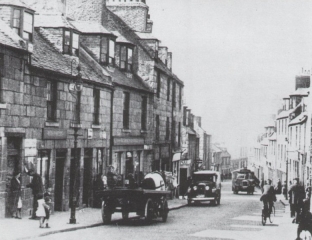
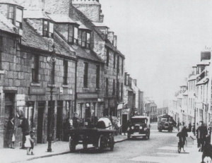
Much of the old toun was swept away in the major slum clearance programmes of the 1890s and 1930s. The Gallowgate, surmounted by the 15th century ‘Mar’s Castle’ – the town house of the Earl of Mar, demolished 1897 – was once compared with the Royal Mile in Edinburgh.

Surely something better could have been achieved than the charmless ‘Brutalist’ Gallowgate we see today? Of the reputedly haunted Guestrow (from Ghaist-Raw), the main remnant is the beautifully restored 16th century George Skene’s House, long known as Cumberland’s Lodging following its requisition by the infamous Duke of Cumberland on his way to Culloden Moor in 1746.

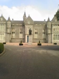
His troops were billeted in what is now Robert Gordon’s College, built 1739 to the design of William Adam, father of the Adam brothers, Robert and James, who are commemorated by the Adelphi Court, the name of which refers to dolphins – a classical symbol of brotherhood.

The Green is thought to be the oldest part of Aberdeen, perhaps properly ‘Green-gate’, meaning the road to the bleaching-greens the banks of the Den-burn; Aberdeen itself was perhaps originally ‘Aber-den’, given that seagoing vessels could come up the Den-burn as far as Patagonian Court.

King William The Lion (1165-1214) was said to have had a Palace on the Green, which he later presented to the Trinity Friars, hence the Trinity Monastery and Chapel, and now, presumably, the Trinity Centre. There was a Carmelite monastery on the south side of the Green, hence Carmelite St. and Lane.  Recent archaeological research suggests that the west end of the Green, close to the confluence of the Denburn and the River Dee, must have been marshy and waterlogged.

It is easy to forget that a full half-mile of Union Street, from the Adelphi to Diamond Street, is an artificial creation

The early or Dark Ages settlement must have been on the drier land at the east end of the Green, pressing up against the steep slope of St. Katherine’s Hill, looking eastwards to Shiprow and northwards up Putachieside to St. Nicholas Kirk. In such a confined space, any significant growth of population would soon have prompted a shift of activity and settlement to the higher and drier land of the Castlegate and Broadgate.

Even now, the streets and wynds around the Green are characterised by very high, narrow buildings, reflecting the tiny medieval plots into which the land was divided. The Castlegate was certainly the main street and market-place by 1290, being referred to, then, as a forum.

Nonetheless, for six centuries, the Green formed part of the only route into Aberdeen from the south. Visitors, both welcome and unwelcome, had to come over the Brig o’ Dee, up the Hardgate, down Windmill Brae, across the Den-burn and through the Green into the old toun. Then as now, the entry to the Green was narrow, but the street then widened out into a triangular shape. It branched off on the left hand into the wynd known as Putachieside and thence to the Netherkirkgate; whilst on the right hand, it led by way of Shiprow round the southern side of St. Katherine’s Hill to the Castlegate – the heart of the medieval Burgh.

Once Union Street and Holburn Street were laid down, the Green, Hardgate etc. et al ceased to be the main or only route to and from the south, and went into a decline.

It is easy to forget that a full half-mile of Union Street, from the Adelphi to Diamond Street, is an artificial creation – a kind of flyover – superimposed on a series of arches vaulting the streets and wynds of the old toun, and at a height of between 20-50 ft. above the natural ground level, which slopes from St. Nicholas Kirkyard down to the Green and the harbour, as did many of the old streets.

Thus Correction Wynd and Carnegie’s Brae run under Union Street whilst  other old streets like St. Katherine’s Wynd or Back Wynd were truncated by it. At the Castlegate end,  Narrow Wynd and Rotten Row were obliterated altogether.

Narrow Wynd was more important than it sounds, and ran across the Castlegate to Shiprow. The famous Aberdeen Philosophical Society, the fons et origo of what became known as the Aberdeen branch of the Scottish ‘Common-Sense’ Philosophy and a major contributor to the ‘Aberdeen Enlightenment’, was founded by Dr. Thomas Reid and Dr. John Gregory, both of King’s College, and held its fortnightly meetings in a tavern in Narrow Wynd from 1758 to1773. The remnant of Narrow Wynd was demolished in 1867 to make way for the new Municipal Buildings or Town House.

The Upper- and Nether-Kirkgate were the roads ‘above’ and ‘below’ the Mither Kirk of St. Nicholas. The narrow street nowadays known as Back Wynd used to be called Westerkirkgate.

The Upperkirkgate Port was the last of the six medieval town gateways to be demolished, sometime after 1794. It stood near the foot of the Upperkirkgate, just beyond No. 42, the gable-ended 17th century house which is still to be seen there now.

The original six ports – solid walls pierced by gateways – had become an obstruction to the flow of traffic, having been in existence from the first half of the15th century.

The other five ports were: the Netherkirkgate Port, controlling movement around the north side of St. Katherine’s Hill; the Shiprow or Trinity Port, checking entry from the south side of St. Katherine’s Hill and the harbour; the Justice or Thieves’ Port to the north-east of the Castlegate, demolished 1787; the Futty Port on Futty Wynd, to the south-east of the Castlegate, and the Gallowgate Port on Port Hill, controlling movement from Old Aberdeen and the north.

Sep 102010
 

Alex Mitchell continues his historical account of the development of Aberdeen, this week focussing on the old  Castlegate.

no images were found

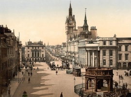
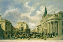
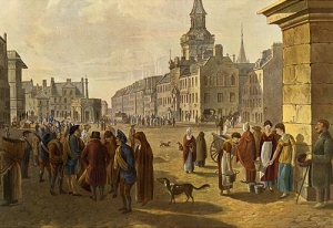
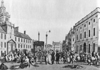
The Castlegate, Broadgate, the Upper and Nether-Kirkgate, Shiprow and Guestrow were once historic and thriving neighbourhoods from the 16th to the 19th centuries.

The old Castlegate was dominated by:

(1) The Tolbooth, dating from 1394, but rebuilt in 1615 and nowadays largely concealed by the frontage of the Town House, built in 1867-72 in Flemish-Gothic style.

(2) The New Inn built by the Freemasons in 1755, visited by James Boswell and Dr. Johnson in 1773. The Freemasons had their Lodge on the top floor, hence the adjacent Lodge Walk. The New Inn was replaced by the North of Scotland Bank, later the Clydesdale Bank, built in 1839-42 as the corner-piece of Castle Street and King Street, and now a pub named after its illustrious architect Archibald Simpson.

(3) Pitfodel’s Lodging of 1530 was the town house of the Menzies family of Pitfodels, a three-storey turreted building, the first private residence in Aberdeen to be built of stone after its predecessor was destroyed by fire in 1529. The Lodging was demolished in 1800 and replaced the following year by the premises of the Aberdeen Banking Company, from 1849 the (Union) Bank of Scotland.

The power and influence of the Menzies family, who were Catholic and Jacobite, was in decline by this time and their old motte-and-bailey castle at Pitfodels, a stone-built tower-house, was in ruins. The associated earthworks were still to be seen at what became the entrance to the Norwood House Hotel until the 1970s, but not much is left there now. The family moved to Maryculter House in the early 17th century. In 1805 John Menzies put the lands of Pitfodels up for sale (also those of Maryculter six years later) and in 1806 purchased 37 Belmont Street (now Lizars opticians). This house had been built in the 1770s and thus pre-dates Belmont Street itself, which was laid down in 1784, well before Union Street.

It is from this house that Mary Queen of Scots is believed to have witnessed the beheading of Sir John Gordon in 1562

In 1831 John Menzies donated his mansion and lands at Blairs to the Catholic Church for use as a college and moved to Edinburgh. He died there without heirs in 1843, the last of the Menzies dynasty, receiving a spectacular Catholic funeral.

Until about 1715 the deceased members of the Menzies family were buried in ‘Menzies Isle’ within St Nicholas Kirk, thereafter in the Kirk-yard. Latterly they were buried at the ‘Snow Kirk’ in Old Aberdeen, just off College Bounds, where the Menzies family grave remains prominent.

(4) Earl Marischal’s Hall dating from about 1540 was next to Pitfodel’s Lodging on the south (harbour) side of the Castlegate. This was the town house of the Keiths of Dunnottar, the Earls Marischal. It had been the Abbot of Deer’s town house but became the property of the (Protestant) Keiths following the Reformation. It consisted of a group of buildings surrounding a central courtyard with gardens attached. It is from this house that Mary Queen of Scots is believed to have witnessed the beheading of Sir John Gordon in 1562 following the defeat of the Gordons of Huntly at the Battle of Corrichie.

Earl Marischal’s Hall was purchased by the Town Council and demolished in 1767 to allow ‘the opening up of a passage from the Castlegate to the shore (or harbour) and erecting a street there’, that being Marischal Street. Before then there had been no direct route from Castle Street to the Quay, and the growth of trade at the harbour made a new street absolutely necessary. Marischal Street was (and still is) a flyover, possibly the first in Europe, vaulting Virginia Street by means of ‘Bannerman’s Bridge’. It was also the first street in Aberdeen to be paved with squared granite setts, the first street of the new, post-medieval Aberdeen and it is the only complete Georgian street remaining in Aberdeen today.

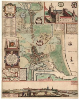
5) Broadgate or Broad Street was the main street of Aberdeen according to Parson Gordon’s map of 1661, lying as it did between the main route north, the Gallowgate and the main (and only) route south via the Green, Windmill Brae and the Hardgate. The old town of Aberdeen never had a High Street as such, probably because St. Katherine’s Hill stood in the way of the most obvious route for a High Street, from the ‘Mither Kirk’ of St. Nicholas to the Castlegate.

A previous resident of Broad Street was the young George Gordon, later Lord Byron. He was born in London in 1788 and was named after his maternal grandfather George Gordon of Gight Castle in Aberdeenshire. The child was brought to Aberdeen in 1790 by his mother Catherine Gordon, after her worthless husband ‘Black Jack’ Byron, had dissipated her inheritance, resulting in Gight Castle being sold to the nearby Gordons of Haddo.

The Castlegate became squalid and dangerous and was notorious for the number and brazenness of the prostitutes

Mother and child lived in lodgings at No.10 Queen Street then moved to No.64 Broad Street. Young George attended the Grammar School at its original location in Schoolhill until 1798, when he inherited his father’s brother’s title and returned to England to continue his education at Harrow, where he was bullied on account of his club foot and Scottish diction.

Castlegate decline

The construction of Union Street from 1801 and the development of the ‘New Town’ westwards of the Denburn encouraged the wealthy and fashionable to migrate in that direction, and the old or medieval town deteriorated throughout the 19th century. The Castlegate became squalid and dangerous and was notorious for the number and brazenness of the prostitutes, who catered for the soldiers in the Barracks and the seamen from the harbour.

The congested old streets and wynds became filthy, infested, stinking and diseased. The courts and closes branching off the Gallowgate were described in 1883 as the dingiest and most unwholesome of any British town. Across the whole Burgh there were still in 1883 some 60 narrow lanes and 168 courts or closes of a breadth of seven feet at most.

The average number of inhabitants per house was reckoned at 14.8 persons. In the St Nicholas Parish the average was 16.8 persons per house. This level of congestion and overcrowding arose because the city’s population was expanding much faster than its geographical boundaries; from 26,992 persons in 1801 to 71,973 in 1851 and to 153,503 in 1901.

Aug 202010
 

Last week in Aberdeen Voice, Alex Mitchell brought us a history of Aberdeen from its recognition by the Romans as a settlement, through its development as two separate burghs, the influence of the burgesses and the benevolence of Robert the Bruce. Part 2 of The Old Burghs of Aberdeen continues.

A Mint was established by the end of the 12th century, most likely at Exchequer Row, which issued coinage in the forms of sterlings, groats and half-groats until the reign of James IV (1473-1513). A weekly Sunday market had been established in 1222 and an annual fair in 1273. The local economy was based on fishing and the processing of wool and leather. Continue reading »

Aug 132010
 

By Alex Mitchell.

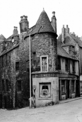
I have been much taken by two illustrated postcards I bought for 10p each in the Ferryhill Library. They depict the long-gone building popularly, if erroneously, known as the Wallace Tower; a once prominent feature of the Netherkirkgate, and are intensely evocative of the old medieval Burgh of Aberdeen, long-predating Union St., King St., Market St., Bridge St., Holburn St. and the later 19th century development of the West End.

The site of Aberdeen has been inhabited since about 6,000 BC. There was a settlement known to the Romans as Devana and identified as such in Ptolemy’s Systems Of Geography of 79 AD. They knew the rivers Dee and Don, which used to conjoin on the Queen’s Links, as the Deva and Devona. Some scholars derive ‘Aberdeen’ from the Pictish-Gaelic aber-devan, meaning ‘at the meeting of two rivers’. It is likely that Roman fleets used the natural harbour at the mouth of the River Dee (Deva) in preparation for their great battle of Mons Graupius against the Caledonians in 83 AD. Thereafter, Aberdeen developed as two settlements: the Royal Burgh of Aberdeen from the mid 12th century which developed around the natural harbour at the mouth of the River Dee and the Episcopal Burgh or Kirk-toun of St. Mary’s from 1498, later the Kirk-toun of Aber-don, which grew up around St Machar’s Cathedral and King’s College and later became known as Old Aberdeen. The two burghs did not become one until 1891.

Trade outside the Burghs was banned. For the residents of a Royal Burgh, the feudal superior was the King himself.

The medieval township was well established as an un-walled trading community by the mid 12th century. Aberdeen was granted the status of a Royal Burgh by King David I (1124-53), with concomitant rights and privileges relating to manufacturing and trade. The effect was that Aberdeen was permitted a degree of autonomy in the conduct of its affairs although it had to conform to the accepted mercantile and burgh law common to England, Scotland and northern France. The trading and other privileges of the older Royal Burgh of Perth were granted to Aberdeen.

It should be realised that markets, fairs etc. could be held only by permission of the landowner or feudal superior. This meant in practice that trade in agricultural and other products could only take place in the fairs and markets of the Burghs which became processing plants for the products of the rural hinterland. Trade outside the Burghs was banned. For the residents of a Royal Burgh, the feudal superior was the King himself. There were none of the usual feudal obligations to any local Earl or lesser landowner but taxes were payable to the Exchequer.

The most powerful of the townsfolk were the burgesses; generally merchants and traders, who had commercial privileges. Only burgesses could own and operate businesses as well as having certain civic responsibilities. Most of the early burgesses came from Flanders, northern France, England and Lothian, bringing with them skills and expertise hitherto lacking in Scotland. They spoke many different tongues, but settled on English as their common language. The burghs became enclaves of English-speakers and their use of English spread outwards to the surrounding hinterlands. In addition, the Royal Burghs, which were almost all east-coast seaports like Aberdeen, Dundee, Perth, Leith and Berwick, had a legal monopoly of trade with foreign countries; in return, the burghs were responsible for the collection of the duties levied on both imported and exported goods and for remitting these revenues, plus sundry rents, fines and tolls, to the Exchequer. The burghs thus became the main source of revenue for the kings of Scotland and, in consequence, the burgesses became men of national significance.

Six members of the Menzies family were Provosts for a total of eighty-three years out of the 16th century alone

Aberdeen’s earliest extant Charter, detailing its privileges, rights and responsibilities, is that granted by William the Lion, grandson of David I, about 1171. In 1211, William the Lion granted his palace in the Green to the Trinity or Red Friars for use as a monastery. The Dominican or Black Friars and the Carmelite or White Friars settled in the same area whilst the Franciscan or Grey Friars had their monastery adjacent to the Broadgate; hence various street and place names still in use in our own time. The Burgh had become an efficient municipal organisation by the 14th century. Its first recorded Provost was Ricardus Cementarius, Richard the Mason, in 1272.

The Burgh had a system of higher and lower courts and a Council drawn from the burgesses of the Merchant Guild of between 12 and 24 members and other officers, sergeants, treasurers etc. In practice, the Council became a self-perpetuating oligarchy dominated by the Menzies family of Pitfodels; successive members of which served as Provosts of Aberdeen for 114 of the 212 years from 1423 to 1635. Six members of the Menzies family were Provosts for a total of eighty-three years out of the 16th century alone including (one such) Thomas Menzies. He served three terms (of) in office – the longest for the period 1547-75 totalling forty years. Aberdeen became something like a European city-state with a single ruling family whose autocracy was, however, subject to the constraint of other burgesses such as the Rutherfords, Chalmers and Cullens.

There was a degree of dictation from the Court and Parliament in Edinburgh and, occasionally, an attempt by neighbouring landowners like the Forbeses, the Gordon’s or the Seton’s to take over the Burgh or to seize some of its possessions. Substantial sums of what amounted to protection money were paid to these families, to keep them at bay.

The Gordons of Huntly were by far the largest and most powerful of the local landowning families and it was to them that the Burgh looked for protection and support. There was a close working relationship between the (burgess) Menzies family and the (aristocratic) Gordons of Huntly to the extent of intermarriage. In 1545, Thomas Menzies resigned as Provost to be succeeded by George Gordon, the 4th Earl of Huntly – the only peer ever to hold that office, albeit for a period of only two years.

But, for most intents and purposes, the Burgh was both independent and autonomous; the more so because of the grant to the Burgh in 1314 by King Robert I (Bruce) of the Royal Forest of Stocket. This became the basis of the Common Good Fund and guaranteed the Burgh a substantial source of revenue such as could finance significant investments and improvements thereafter. Another of the many benefactions from Good King Robert was the Brig o’ Balgownie, built at his order across the River Don in 1320 to facilitate trade with the lands of Buchan, Formartine and the Garioch.

King Robert’s daughter Matilda married Thomas Isaac, the Town Clerk of Aberdeen, and his (Bruce’s) sister Christian latterly lived and died in Aberdeen. These things are indicative of the Bruce’s close relationship with, and affection for, the Burgh of Aberdeen and its citizens.

Aug 062010
 

By David Innes

Aberdeen Football Club in the Scottish Qualifying Cup by Chris Gavin. Published by AFC Heritage Trust. 76 pages. £5.99


Published under the auspices of Aberdeen FC Heritage Trust, this first historical book in a planned series is an excellent start and sheds light on the early days of the Dons and their struggle to attain status as a senior club.

Continue reading »

Jun 242010
 
Pittodrie Stadium

It would appear things are not too happy down Pittodrie way at the moment.

On the back of a dreadful season, the Club has lost key players and there seems to be mounting apathy among fans with season ticket sales numbers not expected to break records. There is also a feeling of torpor as the Club finds itself caught in limbo with a large debt, the real chance of a significant drop in income and in the midst of all this, the need to find the finance to move to the proposed community stadium at Loirston.

Yes, there have been happier times, and the fledgling AFC Heritage Trust is doing its best to preserve those memories whilst at the same time keeping fingers crossed that the Dons can emerge from the current apparent gloom and begin challenging for honours again.

Continue reading »