Aug 302013
 

With somewhat uninspiring opening lines such as ‘O Thou! Who rollest in yon azure field’, ’When energising objects men pursue’ and ‘We do not curse thee, Waterloo!’ it’s a wonder that anyone reads Byron nowadays, unless forced by academic requirements, or perhaps an over-enthusiastic zeal for the great days of the celebrated Romantic Poets. Duncan Harley looks at the truth and myths surrounding this enigma.

 Gight Castle. Image Credit: Duncan Harley

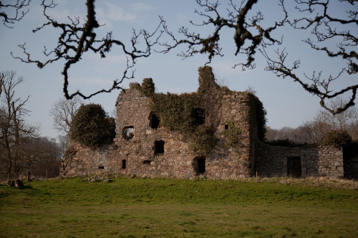
Gight Castle. Former home of Byron’s mother. Image Credit: Duncan Harley

Byron remains popular and his following is undiminished. He wrote of course, amongst other works, Don Juan.
In the classic version, Don Juan is portrayed as a wealthy Lothario and libertine who devotes his life and soul to the seduction of women. His life is also punctuated with bouts of extreme violence, instances of murder and, almost inevitably, lots of gambling.

The tale’s ending depends on which version of the legend one reads.

Tirso’s original play has been interpreted as a religious parable warning against Don Juan’s sinful ways and ends with him dying, having been denied salvation by God. Other authors and playwrights have interpreted the ending in their own fashion. Espronceda’s Don Felix walks into hell and to his death of his own volition, Zorrilla’s Don Juan asks for a divine pardon. The figure of Don Juan has inspired many interpretations.

Byron’s version, however, reverses the classic womanising image of legend, portraying the protagonist not as a womaniser, but as a man easily seduced by women. Written over 16000 lines of verse, Byron himself called it an ‘epic satire’ which indeed it is.

There is much more to the poet though. Born in 1788 in London, and still regarded as one of the greats of British poetry, in Greece he is still revered for having fought for Greek independence from Ottoman Empire rule. In some ways, his life, if you discount the numerous love affairs, aristocratic excesses and that slightly scandalous sexual affair with his half sister, mirrors that of Eric Blair, the author George Orwell.

Blair’s experiences in the Spanish Civil War might not be too different from those of Byron in the Greek Civil War of Independence. Between 1821 and 1832, Russia, the United Kingdom, France, and several other European powers fought the Ottoman Empire. Byron was for the Greeks and against the Turks and went so far as to die for the cause in April 1824, aged just 36.

he could have reversed the state of anarchy amongst the Greeks

In truth, he died of fever and not of heroic battle wounds, but given his romantic disposition, had he been able to tell of his own demise he would no doubt have immortalised his death in heroic romanticised stanzas.

The good folk of Greece, and in particular the folk of Missolonghi where Byron died, still commemorate his arrival in January 1824, during a lull in the war with Turkey. There are those who to this day feel that he could have reversed the state of anarchy amongst the Greeks and brought the conflict to a swifter end.

Who was this man?

A poet obviously and a great one. A romantic, of course, who lived life to the full.

An Aberdonian? Well almost.

Byron’s mother was one Catherine Gordon of Gight. There are, of course, a whole lot of Gordons, from Moray to Aberdeenshire who ruled and feuded for centuries. A Gordon fell at Flodden, another in Flanders and they murdered each other without mercy over the years, waging war amongst themselves with predictable results. There are many Gordon Castles in NE Scotland and most are in either ruins or new ownership.

Catherine Gordon of Gight however topped the lot in some ways.

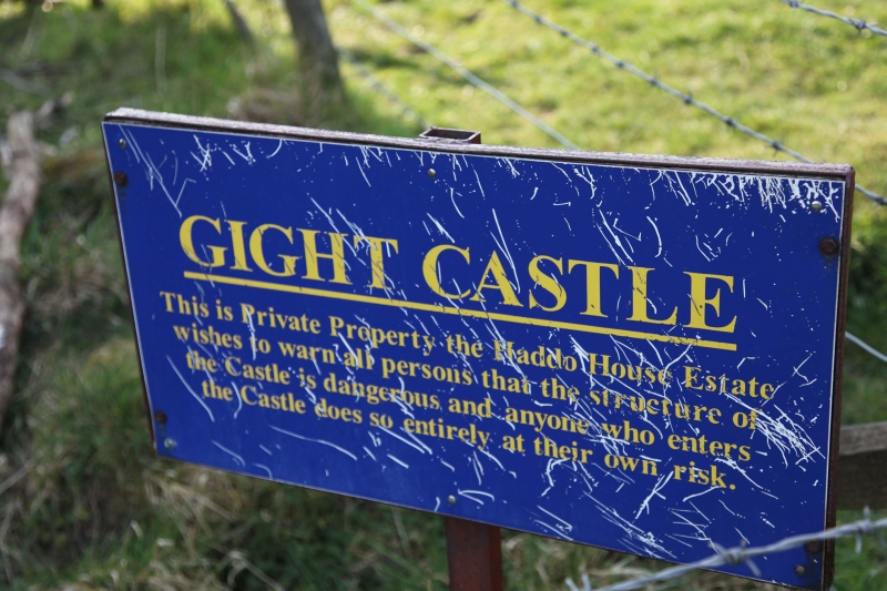
Gight Castle is a ruin nowadays. Set in a place of some beauty and difficult to get to, it was described by Cuthbert Graham in his Grampian: the Castle Country as being associated ‘from first to last’ with a race whose story was ‘crowded with murder and sudden death’.

Gight Castle Sign. Image Credit: Duncan Harley George Gordon built Gight Castle in 1560. In line with the defensive thinking of the time, it resembled Delgatie Castle in design, measuring around 70ft by 50ft and built on an L-plan and may have been commissioned from the same architect. Unlike Delgatie, it has not survived the ravages of the last half millennium.

Catherine Gordon had the misfortune to marry a man known as Mad Jack Byron, a conspicuous gambler and Coldstream Guards Officer.

After Mad Jack had squandered most of her fortune and deserted her, Mrs Byron took her infant son to Aberdeen, where they lived in lodgings on a meagre income.

Meanwhile, Mad ‘Foulweather’ Jack died in 1791 aged 35 at Valenciennes in Spain. Lord Byron would tell friends that his father had cut his own throat, but that may be an exaggeration.

Byron junior attended school in Aberdeen and lived for a while in Queen Street. Whilst his impoverished mother drank, he attended Aberdeen Grammar School before launching himself into what some consider to be a romantic repeat of his father’s attempts to gain happiness and fulfilment in a life misspent.

The lands and castle of Gight were sold to pay off Mad Jack’s gambling debts and the rest is history. The ruin remains and nowadays sheep graze on what might have been Lord Byron’s legacy. Perhaps I prefer the poetry though.

There is, I am told a pub in Aberdeen’s Northfield named after the man. Now, that is an accolade indeed.

  • Comments enabled – see comments box below. Note, all comments will be moderated.
Feb 182011
 

By Alex Mitchell.

A bright, sunny Thursday afternoon. Left the car at Union Square and walked through the main aisle. A fair number of mostly young people are walking briskly and purposefully to and fro rather than window-shopping or going into any of the shops, other than Apple. Out on to Guild Street. The Edwardian frontage of the Station Hotel (1901) looks well in the bright sun.

Across Guild Street and into the recently-designated ‘Merchant Quarter’ around the Green. This whole area, as around the triangular site of the Carmelite Hotel – Trinity Street, Carmelite Street & Lane, Stirling Street and Exchange Street – is characterised by narrow streets, alleys and wynds, small medieval plots and very tall buildings which shut out the sunlight. The overall effect is dark, congested and Gothic, a bit like the medieval Paris depicted in Dieterle’s film of The Hunchback Of Notre Dame (1939).

There is also a marked absence of green space or trees. As part of The Green Townscape Heritage Initiative, ACC has laid down concrete rectangular enclosures for shrubs and trees, as in Carmelite Street and Rennie’s Wynd, but these will take time to establish themselves.   The Green itself is in deep shade at 1.30 pm, with nobody much going about.

Out by Hadden Street, on to Market Street and along Trinity Lane to Shiprow.   The huge City Wharf development, originally scheduled for completion in December 2009, was left unfinished when the Edinburgh-based developer, Kenmore, folded. The development is now owned by SI City Wharf Ltd, and what is striking is the lack of any apparent urgency to finish the job. Even the Ibis Hotel, which was relatively well advanced, remains as yet unfinished. The Harbour is full of oil vessels. Oil-related activity has surged now that the world price has reached $100 per barrel, comparing favourably with long-run extraction costs estimated at $30-50 per barrel.

Across Union Street and into Broad Street. Marischal College, newly restored, shines brightly in the sunshine, the single most iconic building in Aberdeen.

It is a pity the same treatment cannot be applied to the adjacent and contiguous Greyfriars Kirk.

The Church of Scotland wants £1.25 million for Greyfriars Kirk; but Aberdeen City Council estimate its value as being in the vicinity of zero, given that nobody else wants it and the building is full of dry rot.

Down Queen Street, once an elegant Georgian residential thoroughfare inhabited from 1791 by the young George Gordon Byron, later Lord Byron, and his temperamental mother, Catherine Gordon, heiress to Gight Castle. They later moved to Broad Street and young George attended the Grammar School, then at its original site on Schoolhill.   Now Queen Street and Broad Street have no resident population at all.

Round by Aberdeen Arts Centre, in John Smith’s South Church of 1829 at the crossroads of King Street and North Street. Along East North Street towards the Castlehill roundabout. The new low-rent flats built around the old Timmer Market car park have been finished for some reason in a drab brown/black slate-like material. By contrast, the 1960s tower-block flats on Castlehill, viewed at a distance and in the full glare of the afternoon sun, achieve something like elegance and symmetry.

In by Justice Street to the Castlegate which is barely ticking over. Fifty-odd years ago, this was the city’s main bus/tram interchange. Alex ‘Cocky’ Hunter’s emporium and the Castlegate market were in full swing and the Sick Kids’ Hospital was round in Castle Terrace.

Up on to Castlehill itself by the one-time Futty Wynd. There remain long stretches of substantial granite wall from the C.18th Barracks and the earlier Cromwellian fortifications of the 1650s, and a circular indentation, as of a gun emplacement, overlooking the harbour. The Gordon Highlanders left the Barracks in the 1930s and these impressive Georgian buildings became a form of emergency housing until their demolition in the 1960s. There must still be people around now, between fifty and eighty years of age, who were brought up in that distinctly bleak and austere environment.

The odd thing now is that there must be hundreds of people living in the present blocks of flats, Marischal Court and Virginia Court – the equivalent of a large village – but at 2.30 on a sunny weekday afternoon there is nobody going about on Castlehill apart from a couple of Council workmen. Kids would still be at school at this time of day, but even so the entire vicinity is unnervingly silent and still and full of ghosts.

Down Marischal Street and along Regent Quay. The waters of the old natural harbour reached the foot of the Castle Hill at high tide, a line roughly corresponding to Virginia Street. The area between Virginia Street and the present harbour-front is the old Shorelands, a muddy inter-tidal zone once inhabited mainly by crabs, but reclaimed from the mid-C.18th and since occupied by Commerce Street, Mearns Street, James Street, Water Lane and the lower end of Marischal Street.

The view up Mearns Street is dominated by the shining tower of the Castlehill flats. Virginia Street used to be a narrow and meandering cobbled thoroughfare, but is nowadays yet another urban motorway, wider than it really needs to be and at the expense of much of the old toun. It is an unpleasant experience to walk the narrow footpath as between the Shore Porters’ building and the monster trucks charging straight into the permanent traffic gridlock of Guild Street and Market Street. Back along Shore Lane, across the foot of Marischal Street and past Theatre Lane – an almost subterranean link to Virginia Street and well worth exploring. But not today.

Contributed by Alex Mitchell.

Sep 172010
 

By Alex Mitchell.

Much of the old toun was swept away in the major slum clearance programmes of the 1890s and 1930s. The Gallowgate, surmounted by the 15th century ‘Mar’s Castle’ – the town house of the Earl of Mar, demolished 1897 – was once compared with the Royal Mile in Edinburgh.

Surely something better could have been achieved than the charmless ‘Brutalist’ Gallowgate we see today? Of the reputedly haunted Guestrow (from Ghaist-Raw), the main remnant is the beautifully restored 16th century George Skene’s House, long known as Cumberland’s Lodging following its requisition by the infamous Duke of Cumberland on his way to Culloden Moor in 1746.

His troops were billeted in what is now Robert Gordon’s College, built 1739 to the design of William Adam, father of the Adam brothers, Robert and James, who are commemorated by the Adelphi Court, the name of which refers to dolphins – a classical symbol of brotherhood.

The Green is thought to be the oldest part of Aberdeen, perhaps properly ‘Green-gate’, meaning the road to the bleaching-greens the banks of the Den-burn; Aberdeen itself was perhaps originally ‘Aber-den’, given that seagoing vessels could come up the Den-burn as far as Patagonian Court.

King William The Lion (1165-1214) was said to have had a Palace on the Green, which he later presented to the Trinity Friars, hence the Trinity Monastery and Chapel, and now, presumably, the Trinity Centre. There was a Carmelite monastery on the south side of the Green, hence Carmelite St. and Lane.  Recent archaeological research suggests that the west end of the Green, close to the confluence of the Denburn and the River Dee, must have been marshy and waterlogged.

It is easy to forget that a full half-mile of Union Street, from the Adelphi to Diamond Street, is an artificial creation

The early or Dark Ages settlement must have been on the drier land at the east end of the Green, pressing up against the steep slope of St. Katherine’s Hill, looking eastwards to Shiprow and northwards up Putachieside to St. Nicholas Kirk. In such a confined space, any significant growth of population would soon have prompted a shift of activity and settlement to the higher and drier land of the Castlegate and Broadgate.

Even now, the streets and wynds around the Green are characterised by very high, narrow buildings, reflecting the tiny medieval plots into which the land was divided. The Castlegate was certainly the main street and market-place by 1290, being referred to, then, as a forum.

Nonetheless, for six centuries, the Green formed part of the only route into Aberdeen from the south. Visitors, both welcome and unwelcome, had to come over the Brig o’ Dee, up the Hardgate, down Windmill Brae, across the Den-burn and through the Green into the old toun. Then as now, the entry to the Green was narrow, but the street then widened out into a triangular shape. It branched off on the left hand into the wynd known as Putachieside and thence to the Netherkirkgate; whilst on the right hand, it led by way of Shiprow round the southern side of St. Katherine’s Hill to the Castlegate – the heart of the medieval Burgh.

Once Union Street and Holburn Street were laid down, the Green, Hardgate etc. et al ceased to be the main or only route to and from the south, and went into a decline.

It is easy to forget that a full half-mile of Union Street, from the Adelphi to Diamond Street, is an artificial creation – a kind of flyover – superimposed on a series of arches vaulting the streets and wynds of the old toun, and at a height of between 20-50 ft. above the natural ground level, which slopes from St. Nicholas Kirkyard down to the Green and the harbour, as did many of the old streets.

Thus Correction Wynd and Carnegie’s Brae run under Union Street whilst  other old streets like St. Katherine’s Wynd or Back Wynd were truncated by it. At the Castlegate end,  Narrow Wynd and Rotten Row were obliterated altogether.

Narrow Wynd was more important than it sounds, and ran across the Castlegate to Shiprow. The famous Aberdeen Philosophical Society, the fons et origo of what became known as the Aberdeen branch of the Scottish ‘Common-Sense’ Philosophy and a major contributor to the ‘Aberdeen Enlightenment’, was founded by Dr. Thomas Reid and Dr. John Gregory, both of King’s College, and held its fortnightly meetings in a tavern in Narrow Wynd from 1758 to1773. The remnant of Narrow Wynd was demolished in 1867 to make way for the new Municipal Buildings or Town House.

The Upper- and Nether-Kirkgate were the roads ‘above’ and ‘below’ the Mither Kirk of St. Nicholas. The narrow street nowadays known as Back Wynd used to be called Westerkirkgate.

The Upperkirkgate Port was the last of the six medieval town gateways to be demolished, sometime after 1794. It stood near the foot of the Upperkirkgate, just beyond No. 42, the gable-ended 17th century house which is still to be seen there now.

The original six ports – solid walls pierced by gateways – had become an obstruction to the flow of traffic, having been in existence from the first half of the15th century.

The other five ports were: the Netherkirkgate Port, controlling movement around the north side of St. Katherine’s Hill; the Shiprow or Trinity Port, checking entry from the south side of St. Katherine’s Hill and the harbour; the Justice or Thieves’ Port to the north-east of the Castlegate, demolished 1787; the Futty Port on Futty Wynd, to the south-east of the Castlegate, and the Gallowgate Port on Port Hill, controlling movement from Old Aberdeen and the north.

Sep 102010
 

Alex Mitchell continues his historical account of the development of Aberdeen, this week focussing on the old  Castlegate.

no images were found

The Castlegate, Broadgate, the Upper and Nether-Kirkgate, Shiprow and Guestrow were once historic and thriving neighbourhoods from the 16th to the 19th centuries.

The old Castlegate was dominated by:

(1) The Tolbooth, dating from 1394, but rebuilt in 1615 and nowadays largely concealed by the frontage of the Town House, built in 1867-72 in Flemish-Gothic style.

(2) The New Inn built by the Freemasons in 1755, visited by James Boswell and Dr. Johnson in 1773. The Freemasons had their Lodge on the top floor, hence the adjacent Lodge Walk. The New Inn was replaced by the North of Scotland Bank, later the Clydesdale Bank, built in 1839-42 as the corner-piece of Castle Street and King Street, and now a pub named after its illustrious architect Archibald Simpson.

(3) Pitfodel’s Lodging of 1530 was the town house of the Menzies family of Pitfodels, a three-storey turreted building, the first private residence in Aberdeen to be built of stone after its predecessor was destroyed by fire in 1529. The Lodging was demolished in 1800 and replaced the following year by the premises of the Aberdeen Banking Company, from 1849 the (Union) Bank of Scotland.

The power and influence of the Menzies family, who were Catholic and Jacobite, was in decline by this time and their old motte-and-bailey castle at Pitfodels, a stone-built tower-house, was in ruins. The associated earthworks were still to be seen at what became the entrance to the Norwood House Hotel until the 1970s, but not much is left there now. The family moved to Maryculter House in the early 17th century. In 1805 John Menzies put the lands of Pitfodels up for sale (also those of Maryculter six years later) and in 1806 purchased 37 Belmont Street (now Lizars opticians). This house had been built in the 1770s and thus pre-dates Belmont Street itself, which was laid down in 1784, well before Union Street.

It is from this house that Mary Queen of Scots is believed to have witnessed the beheading of Sir John Gordon in 1562

In 1831 John Menzies donated his mansion and lands at Blairs to the Catholic Church for use as a college and moved to Edinburgh. He died there without heirs in 1843, the last of the Menzies dynasty, receiving a spectacular Catholic funeral.

Until about 1715 the deceased members of the Menzies family were buried in ‘Menzies Isle’ within St Nicholas Kirk, thereafter in the Kirk-yard. Latterly they were buried at the ‘Snow Kirk’ in Old Aberdeen, just off College Bounds, where the Menzies family grave remains prominent.

(4) Earl Marischal’s Hall dating from about 1540 was next to Pitfodel’s Lodging on the south (harbour) side of the Castlegate. This was the town house of the Keiths of Dunnottar, the Earls Marischal. It had been the Abbot of Deer’s town house but became the property of the (Protestant) Keiths following the Reformation. It consisted of a group of buildings surrounding a central courtyard with gardens attached. It is from this house that Mary Queen of Scots is believed to have witnessed the beheading of Sir John Gordon in 1562 following the defeat of the Gordons of Huntly at the Battle of Corrichie.

Earl Marischal’s Hall was purchased by the Town Council and demolished in 1767 to allow ‘the opening up of a passage from the Castlegate to the shore (or harbour) and erecting a street there’, that being Marischal Street. Before then there had been no direct route from Castle Street to the Quay, and the growth of trade at the harbour made a new street absolutely necessary. Marischal Street was (and still is) a flyover, possibly the first in Europe, vaulting Virginia Street by means of ‘Bannerman’s Bridge’. It was also the first street in Aberdeen to be paved with squared granite setts, the first street of the new, post-medieval Aberdeen and it is the only complete Georgian street remaining in Aberdeen today.

5) Broadgate or Broad Street was the main street of Aberdeen according to Parson Gordon’s map of 1661, lying as it did between the main route north, the Gallowgate and the main (and only) route south via the Green, Windmill Brae and the Hardgate. The old town of Aberdeen never had a High Street as such, probably because St. Katherine’s Hill stood in the way of the most obvious route for a High Street, from the ‘Mither Kirk’ of St. Nicholas to the Castlegate.

A previous resident of Broad Street was the young George Gordon, later Lord Byron. He was born in London in 1788 and was named after his maternal grandfather George Gordon of Gight Castle in Aberdeenshire. The child was brought to Aberdeen in 1790 by his mother Catherine Gordon, after her worthless husband ‘Black Jack’ Byron, had dissipated her inheritance, resulting in Gight Castle being sold to the nearby Gordons of Haddo.

The Castlegate became squalid and dangerous and was notorious for the number and brazenness of the prostitutes

Mother and child lived in lodgings at No.10 Queen Street then moved to No.64 Broad Street. Young George attended the Grammar School at its original location in Schoolhill until 1798, when he inherited his father’s brother’s title and returned to England to continue his education at Harrow, where he was bullied on account of his club foot and Scottish diction.

Castlegate decline

The construction of Union Street from 1801 and the development of the ‘New Town’ westwards of the Denburn encouraged the wealthy and fashionable to migrate in that direction, and the old or medieval town deteriorated throughout the 19th century. The Castlegate became squalid and dangerous and was notorious for the number and brazenness of the prostitutes, who catered for the soldiers in the Barracks and the seamen from the harbour.

The congested old streets and wynds became filthy, infested, stinking and diseased. The courts and closes branching off the Gallowgate were described in 1883 as the dingiest and most unwholesome of any British town. Across the whole Burgh there were still in 1883 some 60 narrow lanes and 168 courts or closes of a breadth of seven feet at most.

The average number of inhabitants per house was reckoned at 14.8 persons. In the St Nicholas Parish the average was 16.8 persons per house. This level of congestion and overcrowding arose because the city’s population was expanding much faster than its geographical boundaries; from 26,992 persons in 1801 to 71,973 in 1851 and to 153,503 in 1901.

Aug 132010
 

By Dave Watt.

1) King Edward VII – corner of Union Terrace/Union St by Alfred Drury RA & James Philip.

Connection with Aberdeen: Once caught one of his many doses of clap off a chambermaid who owned an Aberdeen Terrier.

2) William Wallace – colossal bronze statue by W. Grant Stevenson which is by far the cities most famous and is located adjacent to Union Terrace Gardens and opposite His Majesty’s Theatre.

Continue reading »