Sep 172010
 

By Alex Mitchell.

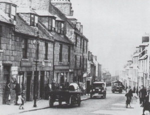
Much of the old toun was swept away in the major slum clearance programmes of the 1890s and 1930s. The Gallowgate, surmounted by the 15th century ‘Mar’s Castle’ – the town house of the Earl of Mar, demolished 1897 – was once compared with the Royal Mile in Edinburgh.

Surely something better could have been achieved than the charmless ‘Brutalist’ Gallowgate we see today? Of the reputedly haunted Guestrow (from Ghaist-Raw), the main remnant is the beautifully restored 16th century George Skene’s House, long known as Cumberland’s Lodging following its requisition by the infamous Duke of Cumberland on his way to Culloden Moor in 1746.

His troops were billeted in what is now Robert Gordon’s College, built 1739 to the design of William Adam, father of the Adam brothers, Robert and James, who are commemorated by the Adelphi Court, the name of which refers to dolphins – a classical symbol of brotherhood.

The Green is thought to be the oldest part of Aberdeen, perhaps properly ‘Green-gate’, meaning the road to the bleaching-greens the banks of the Den-burn; Aberdeen itself was perhaps originally ‘Aber-den’, given that seagoing vessels could come up the Den-burn as far as Patagonian Court.

King William The Lion (1165-1214) was said to have had a Palace on the Green, which he later presented to the Trinity Friars, hence the Trinity Monastery and Chapel, and now, presumably, the Trinity Centre. There was a Carmelite monastery on the south side of the Green, hence Carmelite St. and Lane.  Recent archaeological research suggests that the west end of the Green, close to the confluence of the Denburn and the River Dee, must have been marshy and waterlogged.

It is easy to forget that a full half-mile of Union Street, from the Adelphi to Diamond Street, is an artificial creation

The early or Dark Ages settlement must have been on the drier land at the east end of the Green, pressing up against the steep slope of St. Katherine’s Hill, looking eastwards to Shiprow and northwards up Putachieside to St. Nicholas Kirk. In such a confined space, any significant growth of population would soon have prompted a shift of activity and settlement to the higher and drier land of the Castlegate and Broadgate.

Even now, the streets and wynds around the Green are characterised by very high, narrow buildings, reflecting the tiny medieval plots into which the land was divided. The Castlegate was certainly the main street and market-place by 1290, being referred to, then, as a forum.

Nonetheless, for six centuries, the Green formed part of the only route into Aberdeen from the south. Visitors, both welcome and unwelcome, had to come over the Brig o’ Dee, up the Hardgate, down Windmill Brae, across the Den-burn and through the Green into the old toun. Then as now, the entry to the Green was narrow, but the street then widened out into a triangular shape. It branched off on the left hand into the wynd known as Putachieside and thence to the Netherkirkgate; whilst on the right hand, it led by way of Shiprow round the southern side of St. Katherine’s Hill to the Castlegate – the heart of the medieval Burgh.

Once Union Street and Holburn Street were laid down, the Green, Hardgate etc. et al ceased to be the main or only route to and from the south, and went into a decline.

It is easy to forget that a full half-mile of Union Street, from the Adelphi to Diamond Street, is an artificial creation – a kind of flyover – superimposed on a series of arches vaulting the streets and wynds of the old toun, and at a height of between 20-50 ft. above the natural ground level, which slopes from St. Nicholas Kirkyard down to the Green and the harbour, as did many of the old streets.

Thus Correction Wynd and Carnegie’s Brae run under Union Street whilst  other old streets like St. Katherine’s Wynd or Back Wynd were truncated by it. At the Castlegate end,  Narrow Wynd and Rotten Row were obliterated altogether.

Narrow Wynd was more important than it sounds, and ran across the Castlegate to Shiprow. The famous Aberdeen Philosophical Society, the fons et origo of what became known as the Aberdeen branch of the Scottish ‘Common-Sense’ Philosophy and a major contributor to the ‘Aberdeen Enlightenment’, was founded by Dr. Thomas Reid and Dr. John Gregory, both of King’s College, and held its fortnightly meetings in a tavern in Narrow Wynd from 1758 to1773. The remnant of Narrow Wynd was demolished in 1867 to make way for the new Municipal Buildings or Town House.

The Upper- and Nether-Kirkgate were the roads ‘above’ and ‘below’ the Mither Kirk of St. Nicholas. The narrow street nowadays known as Back Wynd used to be called Westerkirkgate.

The Upperkirkgate Port was the last of the six medieval town gateways to be demolished, sometime after 1794. It stood near the foot of the Upperkirkgate, just beyond No. 42, the gable-ended 17th century house which is still to be seen there now.

The original six ports – solid walls pierced by gateways – had become an obstruction to the flow of traffic, having been in existence from the first half of the15th century.

The other five ports were: the Netherkirkgate Port, controlling movement around the north side of St. Katherine’s Hill; the Shiprow or Trinity Port, checking entry from the south side of St. Katherine’s Hill and the harbour; the Justice or Thieves’ Port to the north-east of the Castlegate, demolished 1787; the Futty Port on Futty Wynd, to the south-east of the Castlegate, and the Gallowgate Port on Port Hill, controlling movement from Old Aberdeen and the north.
Sep 102010
 

Alex Mitchell continues his historical account of the development of Aberdeen, this week focussing on the old  Castlegate.

no images were found

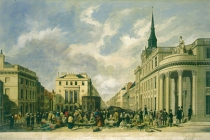
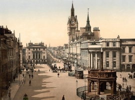
The Castlegate, Broadgate, the Upper and Nether-Kirkgate, Shiprow and Guestrow were once historic and thriving neighbourhoods from the 16th to the 19th centuries.

The old Castlegate was dominated by:

(1) The Tolbooth, dating from 1394, but rebuilt in 1615 and nowadays largely concealed by the frontage of the Town House, built in 1867-72 in Flemish-Gothic style.

(2) The New Inn built by the Freemasons in 1755, visited by James Boswell and Dr. Johnson in 1773. The Freemasons had their Lodge on the top floor, hence the adjacent Lodge Walk. The New Inn was replaced by the North of Scotland Bank, later the Clydesdale Bank, built in 1839-42 as the corner-piece of Castle Street and King Street, and now a pub named after its illustrious architect Archibald Simpson.

(3) Pitfodel’s Lodging of 1530 was the town house of the Menzies family of Pitfodels, a three-storey turreted building, the first private residence in Aberdeen to be built of stone after its predecessor was destroyed by fire in 1529. The Lodging was demolished in 1800 and replaced the following year by the premises of the Aberdeen Banking Company, from 1849 the (Union) Bank of Scotland.

The power and influence of the Menzies family, who were Catholic and Jacobite, was in decline by this time and their old motte-and-bailey castle at Pitfodels, a stone-built tower-house, was in ruins. The associated earthworks were still to be seen at what became the entrance to the Norwood House Hotel until the 1970s, but not much is left there now. The family moved to Maryculter House in the early 17th century. In 1805 John Menzies put the lands of Pitfodels up for sale (also those of Maryculter six years later) and in 1806 purchased 37 Belmont Street (now Lizars opticians). This house had been built in the 1770s and thus pre-dates Belmont Street itself, which was laid down in 1784, well before Union Street.

It is from this house that Mary Queen of Scots is believed to have witnessed the beheading of Sir John Gordon in 1562

In 1831 John Menzies donated his mansion and lands at Blairs to the Catholic Church for use as a college and moved to Edinburgh. He died there without heirs in 1843, the last of the Menzies dynasty, receiving a spectacular Catholic funeral.

Until about 1715 the deceased members of the Menzies family were buried in ‘Menzies Isle’ within St Nicholas Kirk, thereafter in the Kirk-yard. Latterly they were buried at the ‘Snow Kirk’ in Old Aberdeen, just off College Bounds, where the Menzies family grave remains prominent.

(4) Earl Marischal’s Hall dating from about 1540 was next to Pitfodel’s Lodging on the south (harbour) side of the Castlegate. This was the town house of the Keiths of Dunnottar, the Earls Marischal. It had been the Abbot of Deer’s town house but became the property of the (Protestant) Keiths following the Reformation. It consisted of a group of buildings surrounding a central courtyard with gardens attached. It is from this house that Mary Queen of Scots is believed to have witnessed the beheading of Sir John Gordon in 1562 following the defeat of the Gordons of Huntly at the Battle of Corrichie.

Earl Marischal’s Hall was purchased by the Town Council and demolished in 1767 to allow ‘the opening up of a passage from the Castlegate to the shore (or harbour) and erecting a street there’, that being Marischal Street. Before then there had been no direct route from Castle Street to the Quay, and the growth of trade at the harbour made a new street absolutely necessary. Marischal Street was (and still is) a flyover, possibly the first in Europe, vaulting Virginia Street by means of ‘Bannerman’s Bridge’. It was also the first street in Aberdeen to be paved with squared granite setts, the first street of the new, post-medieval Aberdeen and it is the only complete Georgian street remaining in Aberdeen today.

5) Broadgate or Broad Street was the main street of Aberdeen according to Parson Gordon’s map of 1661, lying as it did between the main route north, the Gallowgate and the main (and only) route south via the Green, Windmill Brae and the Hardgate. The old town of Aberdeen never had a High Street as such, probably because St. Katherine’s Hill stood in the way of the most obvious route for a High Street, from the ‘Mither Kirk’ of St. Nicholas to the Castlegate.

A previous resident of Broad Street was the young George Gordon, later Lord Byron. He was born in London in 1788 and was named after his maternal grandfather George Gordon of Gight Castle in Aberdeenshire. The child was brought to Aberdeen in 1790 by his mother Catherine Gordon, after her worthless husband ‘Black Jack’ Byron, had dissipated her inheritance, resulting in Gight Castle being sold to the nearby Gordons of Haddo.

The Castlegate became squalid and dangerous and was notorious for the number and brazenness of the prostitutes

Mother and child lived in lodgings at No.10 Queen Street then moved to No.64 Broad Street. Young George attended the Grammar School at its original location in Schoolhill until 1798, when he inherited his father’s brother’s title and returned to England to continue his education at Harrow, where he was bullied on account of his club foot and Scottish diction.

Castlegate decline

The construction of Union Street from 1801 and the development of the ‘New Town’ westwards of the Denburn encouraged the wealthy and fashionable to migrate in that direction, and the old or medieval town deteriorated throughout the 19th century. The Castlegate became squalid and dangerous and was notorious for the number and brazenness of the prostitutes, who catered for the soldiers in the Barracks and the seamen from the harbour.

The congested old streets and wynds became filthy, infested, stinking and diseased. The courts and closes branching off the Gallowgate were described in 1883 as the dingiest and most unwholesome of any British town. Across the whole Burgh there were still in 1883 some 60 narrow lanes and 168 courts or closes of a breadth of seven feet at most.

The average number of inhabitants per house was reckoned at 14.8 persons. In the St Nicholas Parish the average was 16.8 persons per house. This level of congestion and overcrowding arose because the city’s population was expanding much faster than its geographical boundaries; from 26,992 persons in 1801 to 71,973 in 1851 and to 153,503 in 1901.